EXPOSING DEVELOPERS WHO FAIL TO APPRECIATE AND RESPECT COMMUNITY, ENVIRONMENT AND SPIRIT OF THE LAND
Martha Cove Development (Tassels Creek)
Business Age July 22 2009: "The City Pacific-managed developer CP1, meanwhile, announced it had "submitted a proposal" to an undisclosed financier of its $650 million Martha Cove marina development that served it with a letter of non-compliance in June. CP1 is 20 per cent owned by a company controlled by City Pacific founder and former managing director Phil Sullivan. He repurchased the stake in CP1 from construction entrepreneur Daniel Grollo last month".
July 15 2008 Herald Sun: "Troubled developer CP1 is to quit its flagship project, Martha Cove... "
Indigo Developments and Eureka Funds Management will carry on with the development.
"There are fears that many of City Pacific's debt problems could stem from its massive Martha Cove marina development on the Mornington Peninsula. One $110 million facility taken out with the CBA last year by CP1 is secured against the $650 million project.
The Victorian Government lodged a winding-up order against the 92 hectare development last month, which appears outstanding despite City Pacific claiming it put a cheque in the mail. The development owed City Pacific's First Mortgage Fund $62 million on December 31." Age March 5, 2008.
"City Pacific's 30 per cent subsidiary, CP1, is also believed to have sought off-market interest in its Martha Cove project on Victoria's Mornington Peninsula in recent weeks". AFR March 5, 2008
Aug 29 2009: City Pacific Wind Up Order
Aug 11 2009: Martha Cove Marina Developer Goes To Wall
Aug 10 2009: Martha Cove Investors Feel The Heat
Aug 4 2009: City Pacific Loses Control of Mortgage Fund
July 22 2009: City Pacific Concedes Defeat
Nov 12 2008: CP1 Posts $109m loss; auditors fear company no longer a going concern
Sep 13 2008: Coastal Development All At Sea Over Climate
Sep 8 2008: Stormclouds Over Martha Cove
Aug 27 2008: Bank Queries City Pacific-Grocon Venture on $100 million
Aug 27 2008: CP1 Shares Suspended Over Debt Facility Announcement
July 15 2008: Heavy Seas at Martha Cove
July 7 2008: Political Donations Linked to Developers Contractors
June 5 2008: City Pacific Help or a Muddy Hand Rising From the Grave
March 13 2008: City Pacific Stalls for Time on Units Funds
March 5 2008: City Pacific Takes a Nosedive
March 5 2008: By All Accounts City Pacific is in Trouble
March 4 2008: CityPac in Trading Halt After Stock Crash
March 4 2008: Shares in City Pacific Hit New Low
March 3 2008: City Pacific in strife?
February 29 2008: City Pacific Stands By Mortgage Fund Despite Fears Over Property Loans
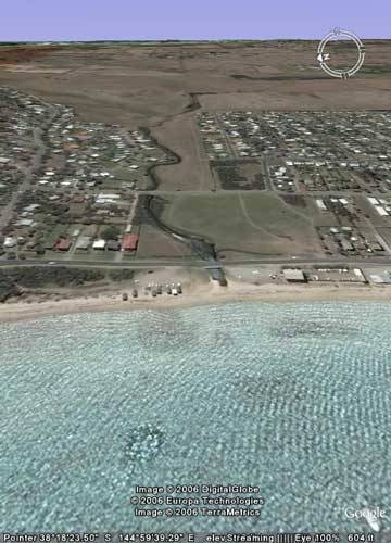
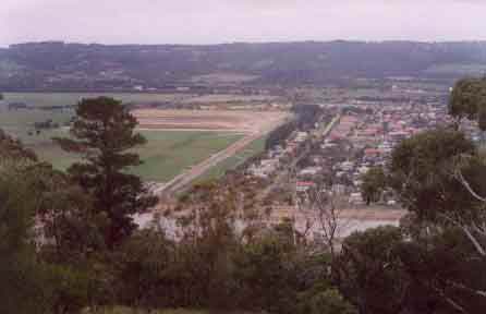
Tassels Creek/Safety Beach, before the madness!

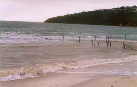
Safety Beach - Port Phillip Bay (red dot on image above).
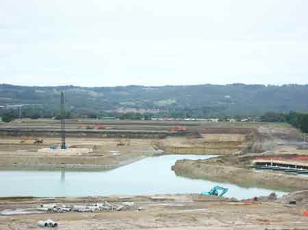
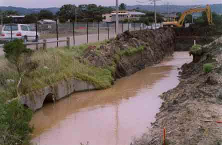
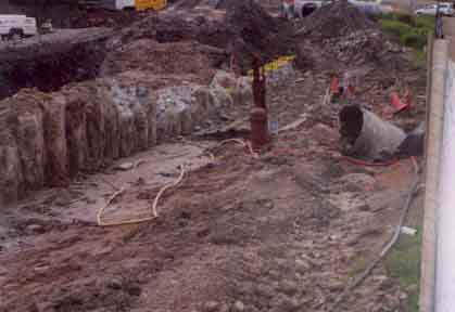
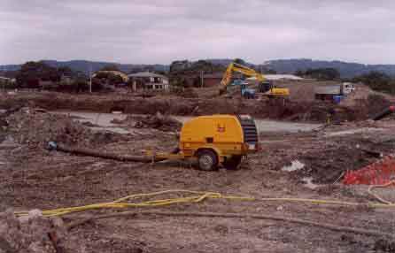
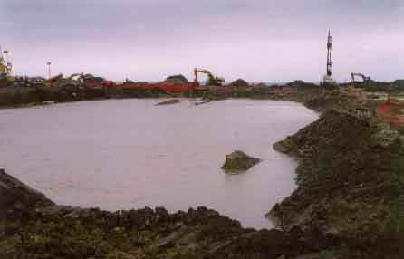
April 2006: Gouging away the Tassels Creek catchment.
Proudly Developed by Marina Cove Pty Ltd*
Proudly Polluting Port Phillip Bay
State president of the Construction, Forestry, Mining and Energy Union (CFMEU), Martin Kingham, claimed the "marina project had been badly managed from the outset". "It comes as no surprise that managements apparent total commitment to put profit above everything else has left the local environment a poor second to bottom line dividends," said Mr Kingham. (The Mail July 1, 2004).
Mozzies, Stagnant Water and Increasing Sea Levels?
Source of the following document about Marinas being built in Tasmania can be found at- http://www.abc.net.au/rn/science/earth/stories/s1149347.htm
" . . .Dr Peter Nutall studied canal estates in Victoria, and says the water is usually stagnant, often smells, and has very little tidal circulation. He says this leads to algal blooms and massive seaweed growth, which ends up on the beach, attracting flies. Tonight, Dr Nutall takes a question from a local about the problem of mosquitoes in tidal canals. APPLAUSE
Questioner: When you said these canals, youve got these canals that are relatively stagnant, did you look at mosquito breeding. Ill tell you why, because we know that Ross River has occurred at Sorell, we know that Ross River virus occurs in Sandford, if they brought all these canals its just going to provide extra breeding sites for the saltwater mosquitoes, and so result in a spread of Ross River virus in this area.
Peter Nutall: Youre absolutely spot on, and that is tidal canals increase the populations of mosquito, and in Patterson Lakes, which I looked at, there were increases of mosquito there. At Painesville, there were increases of a particular mosquito, which is the carrier of Ross River fever, and there is possibly an expectation, certainly with Sorell, which is an epicentre of Ross River fever here in Tasmania, theres a potential for Ross River fever to increase exponentially down here on any tidal canals. And that links to the point that I mentioned about freshwater sitting on top of saltwater. Yes, thanks for that, it was good.
Nicole Johnston: Later at his home in Hobart, Dr Nutall again talks about the insect problem in tidal canals in Queensland. He says a process called stratification occurs, causing water in canals to become stagnant, and insect populations to increase. This is when a layer of saltwater wedges underneath the freshwater creating a barrier to water circulation.
Peter Nutall: Here the stratification is caused by density changes and when you have runoff from the surrounding water its usually bringing in rainwater, and that forms a freshwater on top of the saltwater, so theres no mixing, so therefore you have a halocline, a saltwater stratification, and that locks in the oxygen underneath so that it rapidly becomes deoxygenated, and that will kill off any plant life, any naturally occurring plant life in that underwater area.
Nicole Johnston: The other issue that canal and coastal developers have to consider is rising sea levels due to global warming. Oceanographer with the Co-operative Researcher Centre, Dr John Hunter.
John Hunter: This is a suburb, this is 800 blocks. I think that if youre designing a suburb, you would generally design it for a lifetime of certainly more than 50 years, probably 100 years. If youre designing anything for 100 years nowadays with the knowledge we have at the moment about sea level rise, you probably have to allow for a rise of about a metre in sea level. Now that means that you have to make the flat area of the canal above the water a metre higher than you would otherwise. Now this will undoubtedly cause some problems I suspect for the developer in actually finding enough fill to do that. Its a quicker estimate of how much you need is about a million tonnes of fill to make up that extra 1 metre height that you have to have in order to allow for sea level rise."
Sep 04: Developers get desperate and employ PR firm Scaffidi Hugh-Jones to placate locals. (Source: Martha Cove news Sep 04)
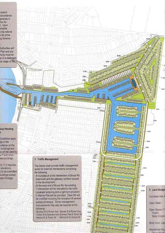
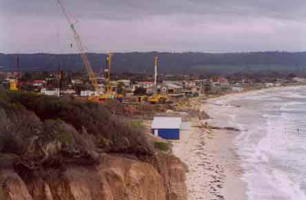
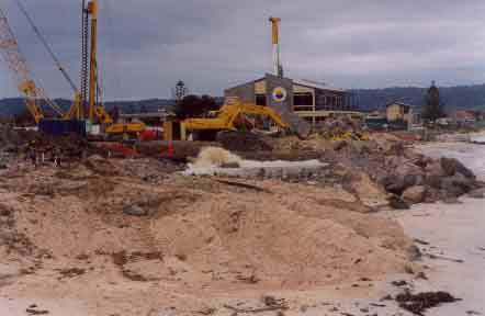
This $650 million development will consist of 1150 residential dwellings, 600 marina berths and 200 dry boat berths and will be built in 5 stages. The site will be constructed by Baulderstone Hornibrook.
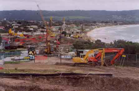
The Outrage
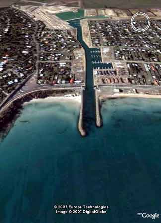
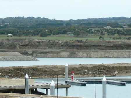
Aerial View of this catastrophe
Corporate Data: Who was to profit mo$t from Martha Cove?
*As of July 2004, Marina Cove Pty Ltd have two shareholders Fish Developments (VIC) Pty Ltd & CP1 Limited. CP1 Limited is a subsidiary of City Pacific Limited. Fish Developments and CP1 each control 25000 shares. Fish Developments (Vic) Pty Ltd is located at Bundall Qld and Maudsland Qld. Its sole Director, secretary and shareholder is John Mervyn Thomas Fish. Therefore Marina Cove Pty Ltd is owned by CP1 Ltd & John Mervyn Thomas Fish. See here for more information on Mr Fish CPI sold their interest off in July 2008
Mr Fish is also causing controversy in Queensland see here
Marina Cove Pty Ltd have two directors: Phillip Keith Sullivan of Broadbeach Waters Queensland & John Mervyn Fish of Sovereign Islands Queensland. Mr Sullivan is also a director of Indigo Pacific, CP1 Ltd and Managing Director of City Pacific Ltd.
Previous Directors of Marina Cove Pty Ltd have included; Bay Ching Chin - Singapore (a director until January 2004), Bay Fah Chin - Singapore (a director until August 2002), Geoffrey Wayne Cleaver*- South Yarra ( a director until July 2002) and Peter Lloyd Rawling - Hawthorn ( a director until July 2002).
Previous Shareholders of Marina Cove Pty Ltd have included Geoffrey Wayne Cleaver (5000), Martha Cove (S) Pte Ltd - Singapore (5000) & Geoffrey Wayne Cleaver 10000. *for more information on Geoffrey Cleaver go to:
http://www.consumer.vic.gov.au/cbav/fairsite.nsf/pages/of_enforceable_undertakings_2003
CP1 Ltd (as of August 1 2004):
CP1 Ltd is located at Queen Street, Brisbane. It's directors are; Ian William Donalson (Sunnybank Qld), Stephen Richard Macbeth Mackay (Mudgeeraba Qld), Stuart Handley Kissick (Benowa Qld), Philip Keith Sullivan (Broadbeach Waters Qld), Thomas William Swan (Robina Qld).
CP1 Ltd Share Structure: 17,640,599 Shares Offered. 7,611,480 Shares Paid.
Contact us for further details on CP1 Ltd
The Outrage
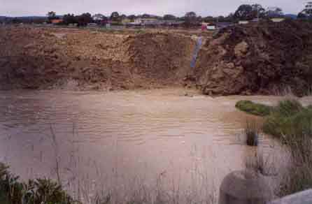
Residents of Safety Beach flooded 27/6/04. (after rainfall of only 25mm).
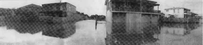
Flooding again 26/7/04 after 10mm of rainfall.
Union Criticises Martha Cove 1/7/04
EES would not have avoided flood: developer 1/7/04
Differing messages on pollution enforcement 1/7/04
Shire investigates Safety Beach flood 8/7/04
EPA : MARTHA COVE DEVELOPERS PUT ON NOTICE
EPA Approval on bay flood control
Second soil dump for Martha Cove by Max Taylor (The Mail)
Developers ready to blame EPA 26/8/04
Flood risk remains for homes 31/8/04
Panel victor goes for more spoils 31/8/04
Inland harbour is proposed 31/8/04
Marina plan digs up Aboriginal land fight 9/1/05
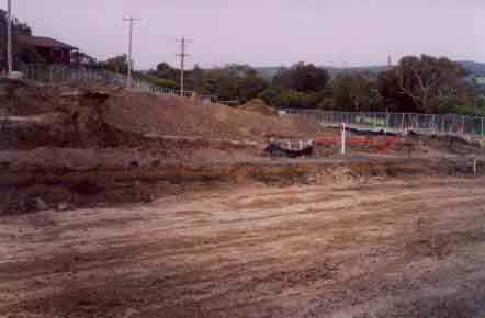
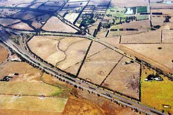
BEFORE

Tassels Ck at Dromana Parade looking west toward Port Phillip Bay - Approximately 1/4 distance inland that marina construction is proposed
AFTER
Union Criticises Martha Cove by Max Taylor July 1 2004 The Mail
The Mail Criticism of the Martha Cove developers for being partly responsible for the heavy flooding of the homes in the Tassells Creek has been backed by the countrys biggest construction union.
State president of the Construction, Forestry, Mining and Energy Union (CFMEU), Martin Kingham, claimed the "marina project had been badly managed from the outset". "It comes as no surprise that managements apparent total commitment to put profit above everything else has left the local environment a poor second to bottom line dividends," said Mr Kingham.
The CFMEU had been "trying for almost a year to have management control of the project tightened". CFMEU local organiser, Gareth Stephenson said: "Weve tried to talk to the principle contractor on the project, Baulderstone Hornibrook, but theyve just ignored us - and now we can all see the result; a large contributing factor to a flood that has devastated the homes of local people."
"We can but hope that Baulderstone Hornibrook senior management will now see the urgency of coming down here and doing something about the situation so that this sort of local disaster doesnt happen again."
EES would not have avoided flood: developer by Max Taylor July 1 2004 The Mail
The completion of an Environmental Effects Statement (EES) specific to the Martha Cove marina would not have avoided the June 26 flood of Safety Beach, according to the developments project manager John Woodman.
But peninsula environmentalists are angry, claiming an EES would have foreseen the potential for flooding.
Mr Woodman said the flood was caused by "intensive rainfall", westerly winds, and strict Environment Protection Authority (EPA) regulations.
An EES was completed in early 1992 when plans were first drawn up for a marina in Safety Beach. However, the current state government declared another one was not needed for the development. "The geography of the land hasnt changed (since then), "Mr Woodman said, "Even if we had carried out an EES, the problem still wouldve arose."
Dromana environmentalist Jenney Warfe, who is also a member of the Mornington Ratepayers Association, said a new EES "would have been appropriate". "The policies of the government in respect to environmental management has changed, so has the community expectation of how we look after our environment", she said.
The Mornington Peninsula Shires director for sustainable environment Alex Atkins said nothing more on drainage matters wouldve been learned from carryout out another EES. "Safety Beach has been subject to inundation for some time - it is a flood plain," he said.
In a letter dated May 23, 2002 Planning Minister Mary Delahunty wrote to the shire: "Given the existence of a current planning permit which reflects the 1992 ministers assessment, the fundamentally unchanged nature of the project and the existence of statutory mechanisms to address new or modified requirements, I am satisfied that the existing ministers assessment remains valid as a basis for the project and its approvals." The ministers assessment, a reference to the 1992 EES, was issued under the Environmental Effects Act 1978 by then Labor Planning Minister Andrew McCutcheon. "We were satisfied with her response," Mr Webb said. He said the shire was "asking questions" of the Martha Cove developers, to ascertain whether or not their environmental management plan took the potential for flooding into account. "Were investigating what led to the occurrence, and what actions the council should pursue," he said. "Our first call is to make sure theres no repeat occurrence."
Peninsula environmentalist Jim Kerin has questioned the shires position on carrying out a fresh EES. "The (original) EES did not assume that the creek would be blocked," he claimed. "How sustainable is the Sustainable Peninsula?"
Mr Woodman said that although there was an environmental management plan in place for the marina development, they couldnt "foresee a combination of rainfall, strong winds, and the stringent EPA requirements". "Obviously (the plan) did not account for this eventuality," Mr Kerin said.
Water overflowed one of the developments holding basins close to the Safety Beach foreshore around midday last Saturday, flooding Marine Dr and Dromana Pde, with water swelling against residential properties. According to the Bureau of Meteorology, Mornington received 31 millimetres of rain in the week ending June 28, with Rosebud receiving 25 millimetres. "It wasnt an outlandish amount of rain," Ms Warfe said. "We saw at least six houses in a row that looked like theyd had their ground floors flooded - people wading around in gum boots, cars in garages with water up to their bumper bars.
Mr Woodman claimed that the extent of the damage done to residential properties was limited to gardens with small quantities of water getting into garages. He said the developers would help residents to "reinstate" their gardens and compensate them for any damage done to indoor carpets caused by "muddy boots".
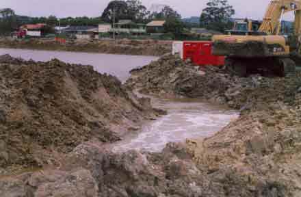
According to Mr Woodman, stormwater collects in a catchment on the eastern side of the Mornington Peninsula Freeway, runs through culverts under the road, and through the site of Martha Cove, whereupon disposal of water becomes the responsibility of the developers.
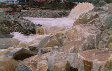
EPA regulations state that the water must be cleaned of all turbidity (mud) before it can be discharged into Port Phillip. "The water is being continuously cleaned, but the process cant be accelerated," Mr Woodman said. "We cant afford to break the EPA regulations. (The flood) was brought about by a storm effect, a government authority, and the construction process. As part of the cleanup, the developers used earth-moving equipment to cut a drainage channel through the Safety Beach foreshore next to the work site, as the flood was deemed to be an "emergency situation".
Untreated storm water escaped into the bay as a result. "There has been some damage to foreshore vegetation, but quite minor," Damien Tonti-Filippini, a member of the Safety Beach Foreshore Landscape Committee, said. "My assessment of it shows that (the foreshore) got out of it quite lightly."
Differing messages on pollution enforcement by Max Taylor and Kimberly Gillan The Mail July 1 2004.
The Environment Protection Authority has said it will not give the Martha Cove developers "a sanction to pollute" the bay, in the wake of the June 26 flooding of Safety Beach. This is despite claims from developers that as of Tuesday they had an agreement with the EPA that would allow them to discharge untreated water into the bay in an emergency situation.
According to Martha Coves Samantha OBrien, there were discussions between the developers and the EPA about "any further occurrence". She said the EPA officer Russell Brown indicated the agency would be very cooperative under any emergency circumstances, and that contact with the EPA should be made by the developers construction crew for a Section 30A, should this occur again".A Section 30A certificate is essentially a licence to pollute, issued by the EPA.
EPA regional manager George Tsivoulidis said yesterday: "If the developers are labouring under the misapprehension that the EPA will allow them to discharge any quality of water at any time they wish, they are wrong."
Mark Briskin of South East Water confirmed that water entered the sewerage system of Safety Beach during the flood, but none entered the bay. "The sewer was contained, and we turned the pump station off as a preventative measure," he said.
Dromana environmentalists had claimed that untreated sewerage flowed into Port Phillip. This was strongly denied by the developers and the EPA claim not to have received any such reports. On Monday, Mr Tsivoulidis said he was considering the EPAs "enforcement options". Believing the flooding could have been anticipated he defended the EPAs regulations against untreated water being discharged into Port Phillip: "There could have been more anticipation of flow levels before the flood occurred". He said the developers were given "practical options" to remove any solid material from the stormwater, "so that they can discharge it quicker, or take it to another point".
Shire investigates Safety Beach flood by Max Taylor July 8 2004 The Mail
The Mornington Peninsula Shire is investigating the cause of the June 26 flooding of Safety Beach. The shire is yet to decide whether the developers are liable, according to its manager for statutory planning Ray Webb. He said the shires main concern was "making sure (the flood) doesnt happen again".
Diverting the storm water runoff that comes from the eastern side of the Mornington Peninsula Freeway before it reaches the Martha Cove development site is an option being examined by the shire and the developers, to avoid a repeat of the flood. "The developers were treating all the water coming off from rural land," Mr Webb said. "If they can prevent it from entering their work site, (the run-off) can continue to flow into the sea."
Currently, water run-off flows through culverts under the freeway and into the marina work site, collecting mud and clay. Once it reaches the work site, disposal of the water becomes the responsibility of the developers. EPA regulations forbid the developers from simply discharging it into Port Phillip, stating the water must be cleaned of all mud and clay beforehand. The turbid water is held in retarding basins by the Safety Beach foreshore. The flood occurred when one of these basins overflowed.
Mr Webb said some of the options for diverting the water include laying a separate pipeline around the work site, at the developers expense.
Martha Coves spokesperson Samantha OBrien said that the developers were working on a plan detailing the steps they have implemented to avoid a reoccurrence of the flood, which they will then submit to the Environmental Protection Authority in an attempt to obtain a Section 30a. A Section 30a is a provision under the Environmental Protection Act 1970, which would allow the developers to discharge turbid water from their retarding basins and into the bay in an emergency situation.
The EPA is continuing its own investigations into the causes of the Safety Beach flood, but has not taken any legal, or enforcement, action, as yet. The EPA has asked the developers to prepare a plan on how it will manage the site in relation to storm water run-off, separate to the developers intention to obtain a Section 30a.
Another flood at 'cove' by Max Taylor - Mornington Peninsula Leader
The Environment Protection Authority is assessing environmental impacts of a second flood at Safety Beach.
Marine Pde and Dromana Pde, Safety Beach were inundated with untreated stormwater in the early hours of last Monday morning, July 26. The floodwater was pumped by Martha Cove contractors.
The EPA met with the developers on Monday but has not yet decided whether it will take any enforcement action against the developers over the second flood in a month.
An incomplete water-diversion channel led to the flood, according to Martha Cove development manager David Newman.
The channel, "just days" from completion, was designed to redirect stormwater run off away from Tassels Creek into Port Phillip.
According to Mr Newman, the channel was 75 per cent complete, with the Martha Cove contractors since being instructed to finish the job before the weekend.
The flood occurred when "overnight rainfall" overfilled the development's holding basins, which house the stormwater run off that enters the work site from culverts under the Mornington Peninsula Freeway, Mr Newman said.
EPA regulations require the developers to clean the water of all mud and clay before discharging it into Port Phillip.
A diversion channel would alleviate the developers of that responsibility.
Mr Newman said the flood was "unexpected".
However, Damien Tonti-Filippini of the Safety Beach Foreshore Landscape Committee said he forecasted another flood the day before, judging from the "expected rising ground water coming in from rains that took place on July 23".
In the week ending July 27, Mornington received 17mm of rain, and Rosebud received seven.
"They're not catering for the natural occurrences of the area," Mt Tonti-Filippini said. He said the flood did not do any damage to the Safety Beach foreshore.
"It was mainly just soaking of the ground and flooding of the road."
Since the first flood, which occurred on June 26, the developers have claimed to be lobbying the EPA for a Section 30a, which would give them permission to discharge untreated water into the bay during an emergency.
EPA regional manager George Tsivoulidis confirmed that the application had been received and was being considered.
The Martha Cove developers were issued with a pollution abatement notice (PAN) in mid July, which detailed the EPA's regulations of how stormwater had to be managed.
"A continuation of adherence to the PAN will significantly reduce the need for a 30a discharge," Mr Tsivoulidid said.
Flash Floods hit again by Tina Hildebrand Mornington Peninsula Leader
Flash flooding has hit Safety Beach for the second time in a month.
Residents living in Marine Drive and Dromana Parade woke on Monday last week to find flood water again covering their yards and the street outside their homes.
The latest flood came exactly a month after water caused damage to 16 homes in the area, sparking an EPA investigation into the nearby Martha Cove development.
The EPA subsequently issued a pollution abatement notice, placing stringent requirements on the developers and contractors to prevent further flooding.
Part of the work to be carried out at the site was the construction of a diversion drain to channel excess water away from homes.
A spokesman for the developer, David Newman, said the flood mitigation work had not been fully completed at the time of the latest flood.
"The contractors had already been undertaking work to redirect flow into a seperate channel, but the works were only 75 per cent complete," he said... Insurance assessors for the project's contractor, Balderstone Hornibrook, are investigating the flood damage.
EPA Approval on bay flood control by Max Taylor Mornington Peninsula Leader
The Martha Cove developers have been given Environment Protection Authority approval to conditionally discharge turbid stormwater into Port Phillip.
The EPA has granted the developers their request for a Section 30a, a provision under the Environment Protection Act 1970 allowing them to pump the untreated water into the bay.
According to the EPA regional manager George Tsivoulidis, a Section 30a could be issued to mitigate "emergency circumstances", but in the case of the Martha Cove development, to relieve the potential for "community hardship" caused by further flooding.
"Often emergencies will impact on the community, and the Section 30a will ensure the local community won't suffer as a result of potential flooding," he said. "It was felt that following the second flood... we needed to provide the community with some assurance they wouldn't be impacted upon."
The permission was effective as of July 28, and will remain valid until August 16, at which time the developers must have their stormwater diversion channel complete.
The diversion channel is designed to intercept stormwater run off from the eastern side of the Mornington Peninsula Freeway before it reaches the work site, and direct the flow into the bay.
After the second flood of Safety Beach, July 26, Martha Cove development manager David Newman said the contractors had been instructed to complete the channel before last weekend.
Mr Tsivoulidis said the EPA would "reassess the situation" if the channel wasn't completed by the August 16 deadline.
"I'd be disappointed if these works weren't completed," Mr Tsivoulidis said. "But there is every indication it will be."
Dromana environmentalist Jenny Warfe believes pumping water that hasn't been cleaned of mud and clay into Port Phillip will effect the bay's entire ecosystem.
"It will increase turbidity, which, when it falls to the floor of the bay, creates sedimentation," she said. "This will choke a lot of marine life and the microorganisms that contribute to the health of the bay...I don't think discharging untreated water into the bay is in keeping with the overarching philosophy of sustainability."
Mr Newman said: "Working to strict environmental guidelines has always been at the forefront of what we do.
"Community safety and good environmental practices are priorities."
He claimed having Section 30a approval was proof the developers "can work closely with environmental agencies, and ensure the best outcome for all involved."
EPA regulations require all stormwater collected at the Martha Cove work site be cleaned before the developers discharge it into the bay.
The two floods of Safety Beach, one on June 26, the other on July 26, occurred when the holding basins overfilled.
As part of the Section 30a, a "monitoring regime" of the Port Phillip ecosystem will be established, including the taking of daily samples of its turbidity levels, which will be forwarded to the EPA for analysis, according to Mr Tsivoulidis.
"We recognise (issuing a Section 30a) isn't an ideal situation, but are of the view there will be no long-term environmental damage (if it is invoked)," he said. "This provides confidence to the community that...(the developers) have the ability to relieve the possibility of flooding as they continue to work towards a permanent environmental solution."
According to Martha Cove spokesperson Samantha O'Brien, the marina contractors make the call on when the turbid water will be discharged.
"There is a list of criteria that needs to be attended to," she said. "As long as they've been met, the contractors can then make that assessment."
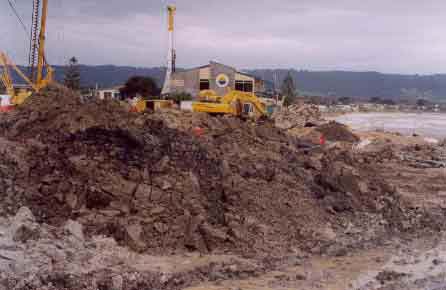
Second soil dump for Martha Cove by Max Taylor (The Mail)
The Martha Cove developers have applied to Mornington Peninsula Shire to dump the soil excavated for the marina's waterways near historic Dalkeith House, Mt Martha.
About three million cubic metres of soil will be taken to the site if approved. The developers bought the land before the Victorian Civil and Administrative Tribunal's June 11 decision to allow another 1.4 million cubic metres of fill on 37 hectares of land in Dromana.
"We always needed another fill site," Martha Cove project manager John Woodman said. He said up to 50 hectares of the "very steep" Dalkeith land would be used.
The land, off Ellerina Rd, offered "magnificent views of Port Phillip and Arthurs Seat". "There are no creek or other wildlife issues to consider," Mr Woodman said. "we'd just be creating rolling hills."
He said the developers did not have any other site if Dalkeith was refused. The shire's manager of statutory planning Ray Webb said it was too early to predict the shire's decision, bet he believed the proposal was "soundly based".
The new dumping site was close to the development and would have minimal impact on roads.
Dromana environmentalist Jenny Warfe said the profits to be generated by the marina development could pay for carting the fill further inland. She said the steep topography of the land would create a lot of surface run-off.
"We have dwindling open space and natural areas left, and this is yet another onslaught on our environment - just because it's closest possible solution to the developer," she said.
Flood Warning 26/8/04 Mornington of Southern Peninsula - The Mail
Developers ready to blame EPA by Max Taylor (The Mail)
The Martha Cove developers would hold the Environment Protection Authority (EPA) responsible if there was another flood of Safety Beach, according to marina project manager John Woodman.
According to Mr Woodman, the EPA had refused to extend the Martha Cove developers' Section 30a despite their "daily requests".
He said the developers needed permission to release the turbid water contained in their holding basins into Port Phillip before the next heavy rainfall.
Claiming the holding basins were already filled to capacity, he said more rain entering the Martha Cove work site before they were emptied would cause a third flood of Safety Beach.
The turbid water, collected from a catchment on the eastern side of the Peninsula Freeway, would take until at least next Thursday to clean to EPA regulations before it would be discharged into the bay, Mr Woodman said. "If they don't issue us with a Section 30a, and it rains again, we will hold the EPA responsible," Mr Woodman said. "The EPA is subjecting residents to unnecessary torment."
The developers started construction on a water diversion channel after the first flood of Safety Beach, June 26, designed to direct runoff around the work site and into the bay. According to Mr Woodman, the channel could not direct all the water at once, with around five per cent of it flowing into the holding basins. This would be enough to cause another flood, he said.
The EPA issued the developers with a Section 30a following the second flood, July 26, allowing them to discharge turbid water into the bay to avoid more flooding. However, it was only valid until August 16, at which time the EPA required the developers to have other flood mitigation measures in place. If it did rain before the holding basins were emptied, the developers would face a $245,000 EPA fine by discharging turbid water into the bay to avoid flooding, Mr Woodman said.
EPA regional manager George Tsivoulidis said he didn't want the "community or environment to be held to ransom over a Section 30a". He said that a Section 30a was not meant to provide a "permanent solution to these types of scenarios". "It would have been preferable for the (development's) flood mitigation measures to be put in place at the outset," he said.
"A section 30a is not there simply to provide a piece of mind to the applicant." He said the EPA had expected the developers to have measures in place that would avoid repeated flooding of Safety Beach by August 16, when their Section 30a became invalid. "That didn't happen - we don't see that as a reason to be issuing a Section 30a, or extending it" he said.
He said the EPA had not instructed the developers to cease pumping turbid water into the bay when they were bringing the two floods under control.
Mornington Peninsula Leader August 31, 2004
Flood risk remains for homes by Tina Hildebrand
Homes close to the Martha Cove project are still at risk of flooding, the developments project manager, John Woodman, revealed last week.
Mr Woodman said the blame lay with the EPA for refusing to extend a section 30a permit to discharge water from the sites holding ponds into the bay. He said the EPA was subjecting residents to "unnecessary torture" over its stance.
"I have written to the EPA chairman Mich Bourke telling hi if they dont issue a 30A I will hold him responsible for any flooding," Mr Woodman said. He said a new diversion drain being built at the site would be able to handle only 95 per cent of the water during a storm. With the sites holding ponds currently full, any excess water during a storm could lead to another flood.
"(During a storm) we would be faced with the decision to either flood the community or start pumping and face a potential fine from the EPA of $245,000 a day," he said. Mr Woodman said stormwater would continue to be a problem at the site until November when the main channel leading from the development to Port Phillip Bay was complete.
But EPA spokesman George Tsivoulidis said the situation was not the fault of the authority. "The lack of pre-planning in their works is responsible for the situation," he said. "The diversion drain is still not finished. If that had been in place earlier it would have reduced the risk of flooding."
Mr Tsivoulidis said the developer had not met all of its commitments under the councils environmental management plan. "If those measures were in place the options they would have to deal with storm water would be significantly more," he said. Two flash floods at the Martha Cove site recently damaged properties and angered residents.
Mornington Peninsula Leader - August 31, 2004.
Panel victor goes for more spoils by Tina Hildebrand
The developer of Martha Cove is seeking council approval to dump spoil from the project on a 50ha parcel of land in Bruce Rd. The move comes just two months after environmental and community groups lost a battle at the Victorian Civil and Administrative Tribunal to prevent the developer from creating a spoil dump at Dromana.
Martha Cove project manager John Woodman said this if approved, the new site would accommodate about three million cubic metres of spoil, more than twice the amount allowed at the Dromana site. But he said he did not anticipate the same level of opposition to the new site.
"There isnt a creek running through the property and there are not the same issues with native plants and animals," he said. The proposed spoil site is part of the historic Dalkeith property, which was subdivided into two lots and sold at auction earlier this year. In June, the tribunal gave the green light to the dumping of about 1.4 million cubic metres of spoil from the marina development on 37ha of land between the Nepean Highway and the Mornington Peninsula Freeway at Dromana. The plan allows for the dumping of spoil up to a height of 7.5m and for the realignment of Brokil Creek.Mr Woodman said the Bruce Rd site was bought after the tribunal decision.
One of the objectors at the tribunal hearing, environmentalist Jenny Warfe, said the new plan was an attempt by the developer to find a cheap solution to the problem of how to dispose of spoil. "I think once again were being expected to offer up our fast-dwindling natural open spaces so that developers can have the cheapest solution to their problems," she said. "Its about time we as a society said enough is enough and make the developers pay their way instead of opting for the cheapest solution. "If that means developers having to pay more to cart their filth to an appropriate site, then bad luck."
Mornington Peninsula Leader - August 31 2004.
Inland harbour is proposed by Tina Hildebrand
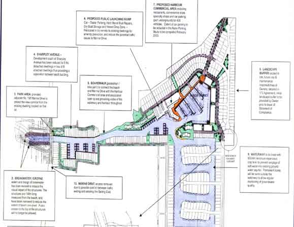
The Martha Cove developer is seeking approval to expand the project into the green wedge zone. An application lodged with the Mornington Peninsula Council outlines plans for an "inland harbour" with 73 extra berths, a commercial aquaculture precinct and extensive public launching facilities.
The new plan allows for up to 200 parking spaces for boat trailers, a dry boat storage area, boat repair and wash down facilities and a four-lane boat ramp. Martha Cove development manager John Woodman said all of the proposed uses were permitted within the green wedge.
He said the boat ramp and other facilities would be of benefit to all recreational boat users. "We want to open the development to the public more. We dont want it to be seen as a public enclave," he said. "It will also provide boat owners with a fully protected retrieval and launch facility, the only one between Portsea and the Patterson River."
Mr Woodman said the provision of berthing for up to six commercial vessels was a response to the State Governments policy of expanding Port Phillips aquaculture industry. The State Government recently tripled the size of the bays aquaculture fields to encourage the commercial farming of blue mussels. Mr Woodman said the industry currently operated from Portarlington Pier as there were no facilities on the eastern side of Port Phillip to unload the harvest.
He said the establishment of an aquaculture industry at Martha Cove would make the development more attractive to tourists. "We see Martha Cove as a modern-day fishing village but it previously lacked the element of fishermen bringing back their produce. It is good from a tourism point of view, as well as employment," he said.
If approved, the inland harbour will be built on a 20 ha parcel of land adjoining the north-eastern boundary of the marina project and will include an extra 5ha of waterways. The application outlines a new access road, also in the green wedge zone, about 60m east of the projects currently boundary.
Environmentalist Jenney Warfe said the new proposal was a "cynical attempt to push the boundaries to the extreme". "The green wedge legislation is there to protect our open space and curb growth," she said. "This application just reinforces the contempt with which the developer treats the community."
Mt Martha Ward councillor Anne Shaw said it was inappropriate to comment on the proposal before it had been properly assessed.
Martha Cove mud fight by Max Taylor September 2, 2004 The Mail
The Martha Cove developers were last week technically allowed to discharge turbid water contained in their holding basins, after they had claimed another flood would be the fault of the Environment Protection Authority (EPA), according to EPA regional manager George Tsivoulidis.
The developers had feared further rainfall before today (Thursday) would cause another flood of Safety Beach, should the EPA not issue them with Section 30a permission to discharge the water into Port Phillip before it was cleaned. Results of turbid water samples taken by the EPA showed that as of last week the water was clean enough to discharge without further treatment, Mr Tsivoulidis claimed on August 27.
"The developers have had the opportunity to take this pressure off their community and the environment and have failed to do so," he said. The developers were issued with a Section 30a by the EPA, valid until August 16, which allowed them to pump turbid water into the bay in emergency circumstances.
Marina project manager John Woodman had claimed further flooding would be the fault of the EPA, which had refused to extend the notice. The results of the EPA water samples were made available to the developers, according to Mr Tsivoulidis. "We would expect the developers to have availed themselves of that opportunity to manage water as per the environmental management plan, which was approved by the Mornington Peninsula Shire, before requesting another 30a," he said.
Mr Woodman said the sample results showed the turbid water was clean enough to be discharged for only one day, August 26. "The reason we didnt begin pumping (on that day) was because we were aware that on the next day, works (on the marina site) adjacent to the bay would elevate the turbidity to an unacceptable level," he said. "So it would have been fruitless to pump it."
He said the developers were aware of the water sample results after "additional" work on the site had begun. It was therefore too late to stop work and start pumping because the onsite additional work made the water in the holding basins move around, which in turn stirred up the turbidity levels, Mr Woodman said. He said the turbidity level of the water in the holding basins east of Dromana Pd, Safety Beach was clean enough to be discharged into Port Phillip as of last Monday, which had begun.
Mr Tsivoulidis re-enforced that it was the developers responsibility to "ensure the development does not adversely impact upon the community and environment". Mornington Peninsula Shire manager of statutory planning Ray Webb said the shire was trying to facilitate further discussion between the EPA and the developers "to see an outcome that makes it clear residents arent adversely impacted by this apparent stand-off". ..
Marina plan digs up Aboriginal land fight
By Mark Russell - Sunday Age 9/1/05
An Environmental group fears tonnes of clay, silt and sand excavated from the $650 million Martha Cove development on the Mornington Peninsula are being dumped on a significant Aboriginal archaeological site.
There have been 245 prehistoric stone artefacts dating back 4500 years unearthed on the 37-hectare site on the Nepean Highway, Dromana.
An archaeological report claims the site is of "high scientific significance".
The Safety Beach Foreshore Landscape Committee wants a museum set up to house the artefacts.
Committee president Tom McCullough has written to the state and federal governments demanding action to protect the site.
The developers of the Martha Cove project, which includes 1100 homes and 600 marina berths, have planning permission to dump 1.4 million cubic metres of excavated soil on the Dromana site, which was previously used for cattle grazing.
The Victorian Civil and Administrative Tribunal put tight restrictions on dumping in June after concerns were raised by residents and the Mornington Peninsula Shire Council.
The maximum height of the dumped excavated material on the site is 7.5 metres. A report last month by archaeologists Melanie Thomson and Stewart Muir said "any cultural material found was replaced in the hole from which it came after being recorded, mapped, photographed".
The report said all of the 10 areas excavated using backhoes had contained Aboriginal stone artefacts, the majority 15 centimetres and 45 centimetres underground. "The site is considered to be of high scientific significance as it contains a wide range and a large number of artefacts in an undisturbed context," it said.
At the VCAT hearing, the Bunurong Aboriginal community said it was satisfied with the way developers were handling the archaeological sites.
The tribunal said further archaeological assessment should be carried out on the land near Brokil Creek (also known as Tassells Creek) where the prehistoric campsite was believed to have been.
It was satisfied the archaeological sites would be protected because the developer had guaranteed the fill would not be placed over the prehistoric sites. VCAT said the archaeological assessment would never have been carried out if the land had been left for grazing.
A spokeswoman for Martha Cove said the developer was doing all it could to protect the artefacts.
The Bunurong Aboriginal Land Council co-ordinator, Steve Compton, said the site was not unusual.
"I dont really know what all the fuss is about," he said. "Compression of the the fill is not going to impact on the artefacts in the subsurface.
"Basically the community gets sick and tired of people wanting to pick these things up all the time and put them in a museum because you remove all evidence of Aboriginal existence from the landscape.
"Sometimes what some people may consider is best for another race of people may not necessarily be what that race of people wants."
Mr McCullough said he could not let the bulldozers go back to the site.
"The point is even if the indigenous community doesnt mind what is happening, a lot of us do because we care about the history of Australia," he said.
"Archaelogists just have to, at times, say Hold on, just delay the building of the supermarket while we dig up the Roman ruins."
Dont bury history 11/1/05 by Matt Doran Mornington Peninsula Leader
The discovery of 4500-year-old Aboriginal artefacts at Martha Cove has sparked a last-minute bid to prevent the site from being "buried forever".
Work on the project has been halted while developers seek State Government approval to push ahead with plans to dump more than a million cubic metres of spoil above the archaeological site.
An investigation into the cultural significance of the site - at 223 Nepean Highway Dromana, near Brokil Creek - found the remains of 245 stone tools and an 800 m-long Aboriginal campsite.
Debate has erupted over what should be done with the artefacts, which are believed to be up to 4500 years old and of "high scientific significance".
A local foreshore committee has called for them to be preserved in a new museum, while Aboriginal representatives argue the artefacts should be left untouched.
But a spokeswoman for the developer labelled the artefacts "nothing out of the ordinary".
The Safety Beach Foreshore Landscape Committee has written to the State and Federal governments, urging them to reject the developers application to continue dumping at the site. "All evidence of prehistoric activities will be buried forever if this goes ahead," committee president Tom McCullough said. "While we understand the developers wish to utilise their land, no justification exists for abandoning and reburying these artefacts," Mr McCullough said. "There is a national, if not international, obligation to find out what this site reveals about our history. This is unique because of the number of artefacts discovered and we should create a keeping place, set up a museum in Safety Beach."
But the Bunurong Aboriginal Land Council, which has been consulting with the developers, said it was not interested in digging up the site to satisfy peoples curiosity. "As long as this site is not developed down the track, we are happy for the artefacts to be buried under a protective geofabric," Bunurong spokesman Stephen Compton said. "The suggestion they be put in a museum is very offensive."
Martha Cove spokeswoman Samantha OBrien said similar artefacts had been found across the peninsula. "We have taken every step to research this site and consult with all parties, including Bunurong representatives. That research has shown these artefacts are not unusual on the Peninsula," she said.
A spokeswoman for Aboriginal Affairs Minister Gavin Jennings said a decision on the future of the site would be made by the end of the month.
Site of Significance Report A report on the site, released last month by Biosis Research, states: "The site is considered to be of high scientific significance as it contains a wide range and a large number of artefacts in an undisturbed context. "The proposed works will impact on the context of the material and effectively hinder future potential of gaining information into land use of the Aboriginal people that once inhabited the region."
Marina Expansion 3/2/05 The Mail by Fran Henke
Martha Cove this week won approval from the Mornington Peninsula Shire to develop a further inland harbour and "modern day fishing village" on rural land behind the marine now being built.
The Queensland-based developers also plan to farm blue mussels off Mt Martha and bring the catch through a lifting bridge into six commercial berths at the new harbour, which they say will spawn a new aquaculture industry with the potential to employ initially 250 people.
This new proposal will permit the developers to add more and smaller allotments within Martha Cove to the 1000 residential blocks originally permitted.
The developers also won approval to dump fill across five hectare parcels of land formerly part of the historic Dalkeith Estate and rural land owned by Bruce Brockhoff. The vast quantities of spoil will create new ridge lines to be resown with pasture grasses and indigenous vegetation.
The new owner of Dalkeith House, Jim Heber, told councillors they had made "a big mistake" in allowing the fill to be dumped adjacent to his property, one of only eight heritage listed houses and gardens on the peninsula. Mr Heber said he was negotiating to buy seven acres from the Martha Cove developers in an attempt to protect a stand of 100-year-old cypresses and the amenity of his house.
Tom McCullough, a member of Friends of Tassells Creek, was appalled that the inland harbour could be built on part of the green wedge. "Where will it end?" Mr McCullough asked.
Peter Kelly said he had moved house because of the impact of construction of the Martha Cove tunnel. Mr Kelly described the process as "a grubby exercise" and accused council of doing everything it can to stop this developer going broke".
Spokesman for Watsons, the town planners, John Woodman, said they were not extending their rights as the harbour and aquaculture was a permitted use within the green wedge. The application also asked for 73 wet berths for larger vessels to be created in the new harbour. Mr Woodman said that since the original permit for Martha Cove was granted 10 years ago, the size of vessels favoured on Port Phillip had increased. It was not uncommon for 10 to 15m long sailing and motor craft to be owned and operated on the bay.
But the passage of the permits was not all plain sailing. Cr David Gibb tried to reduce the number of wet berths from 73 to seven, to restrict sales of fish on site and to put in place controls over further development of the rural land to the east. He described the new activity as "excessive" and "cheeky", saying Mr Woodman was an "excellent spruiker". "When is enough enough?" asked Cr Brian Stahl in his support.
Cr Gibb said he had voted all long to help the development but now would be less likely to give developers the benefit of the doubt. His motion for a 173 agreement as protection failed four votes to five. . .
Aerial View of this catastrophe
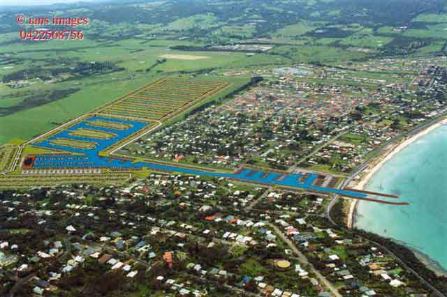
Above - The same developers are about to apply for another permit to dump over 3 million cubic metres of spoil from the marina site on land they've just purchased at 245 Nepean Hwy Dromana - adjacent to a heritage property 'Dalkeith' which has a variation to the heritage listing just appearing on a Planning Scheme amendment doc (Amendment C65) . They just had a big win in VCAT winning the right to dump around 1 million cubic metres of spoil on land (and divert a creek) at 231 Nepean Hwy Dromana. The land in question is the central heavily grazed dry section.